
Dutch Era New York City Transportation
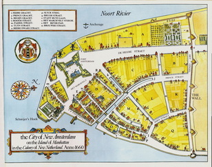 Casltello Plan. The New Amsterdam city in 1660.
1614 to 1664 Dutch had the power in the Manhattan area and it was called New Amsterdam (Dutch- Nieuw-Amsterdam). During that period cities near oceans were mostly built around a port. Fort Amsterdam became the reason to growth of New Amsterdam. Fort Amsterdam was located on the southern tip of the Manhattan Island and the transportation development occurred centering the port. Furthermore the Dutch were took the advantage of the rivers surround the Manhattan island for the transportations. The cheap European manufactured knives, axes and other steel tools were transported to the Fort Amsterdam and locally collected clothes and curved pelts were exported from Fort Amsterdam (1). They also made canals for the transportation and it’s shown on the Casltello plan. There were a canal on the todays Broad Street which was called the Heere Gracht. In 1658 the first regional road was built from Nieuw Amsterdam to Nieuw Haarlem (today’s upper Manhattan) and it was a wagon-road.
1. Edwin G. Burrows, Mike Wallace.Gotham:A History of New York City to 1898. New York: Oxford Press. (1999). Print.
